Colorado has a total of 26 byways, with 11 designated as America’s Byways®, giving the state more national designations than any other state. Three of those 11—Dinosaur Diamond Prehistoric Highway, Santa Fe Trail and Trail of the Ancients—also cross into neighboring states. View the Colorado Scenic and Historic Byways Virtual Guide and the Colorado Byways website for more information.
Note: Before heading out, get the latest on travel conditions and guidance for visitors in the What’s Open online guide, or call 800-COLORADO to speak to a traveler counselor. The Travel Center has information maximum grades on mountain passes and COtrip.org has the latest road conditions. Driving in the winter? Visit the Winter Driving page. Also, check the COVID-19 web page on the Colorado.gov site. Please be aware that, as of this writing, face coverings are mandatory in indoor public spaces.
America’s Byways® in Colorado
Colorado River Headwaters Byway
The 69-mile Colorado River Headwaters Byway traces one of the country’s mightiest rivers from its source. Along the way, it offers views of mountain landscapes, reservoirs, ranchlands and narrow canyons as it drops 1,700 feet in elevation from end to end.
Dinosaur Diamond Prehistoric Highway (Colorado, Utah)
At 480 miles in length, the diamond-shaped loop that is the Dinosaur Diamond Prehistoric Highway not only travels through two states but also back in time, where travelers can see the bones and tracks of dinosaurs who once walked the land.
Frontier Pathways Scenic and Historic Byway
Frontier Pathways Scenic and Historic Byway is a 103-mile route, with views of rugged mountains, fields of delicate wildflowers, foothills dotted with piñon pines and stands of golden aspen. Campgrounds and picnic areas can be found along the route, with some having user fees.
Gold Belt Tour Scenic and Historic Byway
The 135-mile Gold Belt Tour Scenic Byway connects six of the state’s major historic towns, following historic railroad and stagecoach routes that lead to the greatest gold camp, three world-class fossil sites, and numerous historic sites.
Grand Mesa Scenic and Historic Byway
At 63 miles in length, the Grand Mesa Scenic and Historic Byway begins on the Plateau Canyon floor and then climbs to what is called the “playground in the sky”: evergreen mesa forests 11,000 feet up. There are overnight campground fees per USFS schedules and private campground fees.
Lariat Loop Scenic and Historic Byway
Just 40 miles in length, the Lariat Loop Scenic and Historic Byway nevertheless has much to offer. As one of the first historic byways in the country, the Lariat Loop has two portions that are on the National Register of Historic Places: the Bear Creek Canyon Scenic Mountain Drive and the Lariat Trail Scenic Mountain Drive. The Loop, resting on the edge of the Denver metropolitan area, has three dozen historic sites and buildings taking visitors back in time to the days of the Wild West.
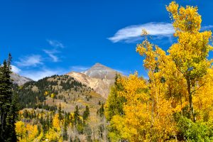
San Juan Skyway
At 233 miles in length, the San Juan Skyway, known as the “road to the sky,” offers visitors diverse views to enjoy: the 14,000-foot San Juan Mountains, rolling hillsides with ancient Indian pueblo ruins and Victorian towns.
Santa Fe Trail (Colorado, New Mexico)
The Santa Fe Trail is 565 miles, making it the longest in this list. It begins at the Colorado-Kansas state line and crosses into New Mexico where it terminates in Santa Fe. The Santa Fe Trail was one of the country’s first great trade routes, and travelers can visit historic sites and landmarks while enjoying spectacular scenery.
Top of the Rockies
The Top of the Rockies, so named because the altitudes rarely dip below 9,000 feet, covers 75 miles. Along the way it twice crosses the Continental Divide as it traces the Arkansas River and takes travelers to historic mining towns including Leadville, the highest incorporated community in the U.S.
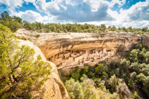
Trail of the Ancients (Colorado, Utah)
The 480-mile double-loop Trail of the Ancients crosses into Utah from Colorado and then back again, with highlights such as Mesa Verde National Park, Monument Valley Tribal Park and Four Corners Monument along the way. Home to Native American peoples who occupied the Four Corners region, the Trail explores the diverse and beautiful Colorado Plateau landscape.
Trail Ridge Road/Beaver Meadow Road
Holding the distinction of being America’s highest continuously paved road, the 48-mile-long Trail Ridge Road/Beaver Meadow Road has overlooks that provide travelers with views of peaks ranging from 12,000 to over 14,000 feet. With 11 miles of the route above tree line in the alpine tundra, visitors have a chance to see forms of life and climatic conditions that are also found at the Arctic Circle. Park entrance fees are required, with different rates based on type of access (vehicle, bicycle, motorcycle or pedestrian).
Other blogs in this series:
- Take a Scenic Drive through Idaho
- Take a Scenic Drive through Tennessee
- Take a Scenic Drive through Kansas
- Take a Scenic Drive through Illinois
- Take a Scenic Drive through Washington State
Recent Articles
